We recently worked on a 25-foot cut for a warehouse expansion near the Tuolumne River in Modesto. The water table sat at 9 feet, and the soil profile showed interbedded sands and clays typical of the San Joaquin Valley floodplain. For that project, we ran limit-equilibrium analyses using Spencer's method, which handles both circular and non-circular failure surfaces. Before modeling, we confirmed the shear strength parameters with direct shear tests on undisturbed samples. The analysis gave us a factor of safety of 1.42, just above the 1.3 minimum for temporary cuts per IBC 2021. That margin allowed the contractor to proceed without soil nails.
For saturated silts in Modesto's floodplain, a 2:1 slope can fail at 28 degrees friction angle without drainage control.
Methodology and scope
West Modesto, near the airport, has older alluvial fan deposits with higher gravel content and better drainage, while neighborhoods south of Highway 99 sit on younger floodplain silts that stay saturated for weeks after winter rains. Those differences directly affect slope stability. In the silty zones, we see lower effective friction angles — around 28 degrees — and higher pore pressures during storm events. That combination can drop the factor of safety below 1.0 if the slope is steeper than 2:1. Our team adjusts the analysis for each soil unit and uses piezometer data from field tests to model worst-case wet-season conditions. We also check for seepage parallel to the slope face, a common trigger for shallow failures in Modesto's alluvial terraces.
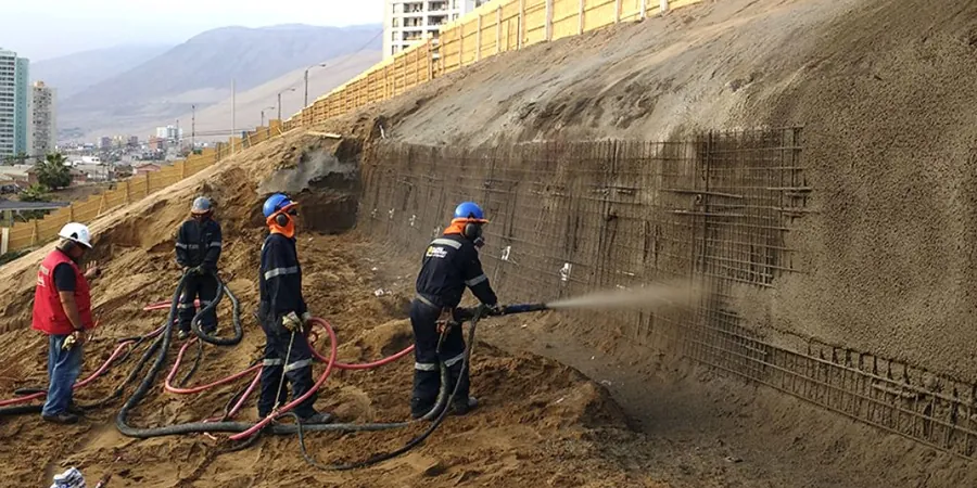
Technical reference image — Modesto
Local considerations
Modesto's Mediterranean climate brings dry summers and concentrated winter rainfall. The heaviest storms hit between December and February, when the ground is already saturated from previous events. That seasonal saturation can reduce effective stress in the slope by 30 percent or more. For cuts left open through the winter, we require either a temporary drainage blanket or a cover of reinforced geomembrane to prevent surface erosion and infiltration. We also model rapid drawdown conditions for slopes adjacent to irrigation canals, which are common in Stanislaus County. Ignoring that transient seepage can trigger failures weeks after the rain stops.
We model circular and non-circular failure surfaces using Bishop Simplified and Spencer methods. We incorporate measured shear strength from triaxial or direct shear tests, plus pore pressure data from field piezometers. Deliverables include factor-of-safety contours and recommended cut slopes for each soil layer. Typical turnaround is 5 business days for a single cross-section.
02
Remediation Design for Failed Slopes
When a slope has already moved or shows tension cracks, we perform back-analysis to estimate mobilized strength. Then we design stabilization solutions: retaining walls, soil nails, or drainage systems. We check each option against the same limit-equilibrium models used for the initial analysis. We coordinate with structural engineers on tie-back anchors and with the city of Modesto on grading permits.
What is the typical factor of safety required for slope stability in Modesto?
For permanent slopes under IBC 2021, the minimum factor of safety is 1.5 under static conditions and 1.1 under seismic loading. Temporary cuts (open less than 6 months) can use 1.3 static. We always confirm with the local building department, but those are the baselines.
How much does a slope stability analysis cost in Modesto?
For a single cross-section with field data included, the range is US$1,100 - US$3,650. That covers the limit-equilibrium model, sensitivity analysis, and a report with recommendations. Complex projects with multiple sections or groundwater modeling may fall at the higher end.
Do I need a slope stability study for a residential retaining wall?
Not always. For walls under 4 feet in stable soil, the city typically waives the analysis. But if the wall retains more than 6 feet of fill or is built on the silty clays south of Highway 99, we recommend at least a screening analysis. We have seen walls fail in that area due to undrained loading after heavy rain.
How do you handle groundwater in the stability model?
We install two piezometers at the slope toe and crest before drilling. We measure the phreatic surface during wet-season conditions. In the model, we simulate steady-state seepage parallel to the slope. If the water table is within 10 feet of the surface, we recommend a drainage blanket behind the wall or cut.
Can you run the analysis based on existing geotechnical reports?
Yes. If you have a previous soil report with shear strength data (direct shear or triaxial) and a boring log with groundwater observations, we can run the model from that data. We will note the limitations in the report and recommend additional testing if the data is older than 5 years or from a different season.