A retaining wall along a commercial lot near the Tuolumne River in Modesto started showing hairline cracks last spring. Surface runoff from unseasonal rain had saturated the backfill, and the wall鈥檚 drainage system wasn鈥檛 keeping up. That鈥檚 exactly the kind of situation where monthly slope monitoring catches movement before it becomes a failure. We install inclinometers, piezometers, and surface survey markers to track displacement and pore pressure trends. Before setting up a monitoring plan, we also recommend a geotechnical soil study to classify the native soils and establish baseline conditions. For Modesto鈥檚 alluvial terrain, that step is critical.
Monthly slope monitoring detects movement trends early, giving engineers time to act before a failure event occurs in Modesto.
Methodology and scope
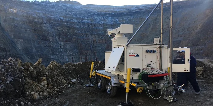
Our monthly monitoring program uses high-resolution ShapeArray inclinometers and automated dataloggers that record readings at programmable intervals. The equipment is weatherproof and runs on internal batteries for up to three months between site visits. We also install vibrating-wire piezometers for pore pressure tracking and surface prisms for total station surveys. The field team visits Modesto once per month to download data, inspect instrumentation, and perform manual survey checks. Data is processed in our lab using software that compares each reading to the previous cycle. Threshold alarms are set per project criteria, and we integrate results with CPT soundings when subsurface profiles need higher vertical resolution.
Technical reference image — Modesto
Local considerations
Modesto鈥檚 Mediterranean climate brings dry summers and concentrated winter rains that can quickly saturate clayey silt layers. The underlying alluvial deposits from the Tuolumne River are prone to internal erosion and piping when stormwater concentrates along slope faces. Without monthly monitoring, a gradual loss of soil strength goes unnoticed until tension cracks open and a failure surface develops. We鈥檝e seen slopes that looked stable in June become unstable by January. The risk is real, especially near drainage channels and highway embankments where geometry changes rapidly.
Permanent casing grouted into a borehole with ShapeArray or manual probe readings taken monthly.
02
Piezometer Monitoring
Vibrating-wire and standpipe piezometers installed at critical depths to track pore pressure changes.
03
Surface Survey and Crack Monitoring
Total station survey of prisms and telltales placed on slope faces and structures.
04
Data Analysis and Reporting
Monthly reports with displacement graphs, trend analysis, and threshold alarms for engineers.
Applicable standards
ASTM D6230-18 (inclinometer calibration and installation), FHWA-NHI-05-124 (slope monitoring guidelines), ASCE 7-22 (earth pressure and surcharge loads)
Frequently asked questions
How does monthly slope monitoring work for Modesto projects?
We install inclinometer casings, piezometers, and surface markers at selected locations. A team visits the site once per month to take readings, download datalogger data, and inspect for visual changes. The data is analyzed in our office and compared to previous cycles. If movement exceeds a pre-set threshold, we issue an immediate alert. This approach suits slopes with moderate risk that don鈥檛 require real-time telemetry.
What are the typical costs for monthly slope monitoring in Modesto?
Monthly monitoring programs in Modesto start around US$390 for a basic surface survey package and go up to US$1,430 for a full program with deep inclinometers, piezometers, and monthly reports. The actual cost depends on the number of instrument locations, depth of casings, and access conditions. We provide a fixed monthly rate after the initial installation is complete.
How long should slope monitoring continue in Modesto?
That depends on the slope鈥檚 activity. If movement stabilizes after two consecutive dry seasons with no acceleration, monitoring can often be reduced or stopped. For slopes near infrastructure, many owners continue monitoring for the life of the project. We recommend a minimum of two years for any slope that showed signs of instability during construction.
What happens if the monitoring detects movement in Modesto?
If displacement exceeds the project-specific threshold, we send a formal alert within 24 hours. The data helps the engineer decide on corrective actions: improved drainage, surface sealing, buttressing, or slope regrading. We can also increase monitoring frequency to weekly if needed. Early detection in Modesto鈥檚 clayey silts often prevents costly emergency repairs.