Modesto grew fast after the railroad arrived in 1870, turning orchards into neighborhoods. That history matters because the top 20 feet of soil here is mostly young alluvium from the Tuolumne River floodplain. Soft silts and loose sands dominate the upper profile, with the water table sitting 10 to 15 feet down in many blocks. Before you pour a single yard of concrete, you need to know how that ground will behave under load. That is where geotechnical instrumentation comes in. We design and install monitoring systems that track movement, pore pressure, and settlement in real time. A recent project on McHenry Avenue required continuous piezometer readings because the excavations stayed open for weeks in wet ground. Combining those readings with a [MASW survey](/masw-vs30/) helped us map the soft layer thickness across the site. Without that data, the shoring design would have been guesswork.
The top 20 feet of Modesto soil is young alluvium from the Tuolumne River floodplain – loose sands and soft silts that demand continuous monitoring.
Methodology and scope
We use vibrating-wire piezometers, in-place inclinometers, and automated data loggers that upload to the cloud every 15 minutes. The hardware is solid enough for Modesto's hot, dry summers and the occasional atmospheric river event in winter. Each installation starts with a detailed drilling plan. We push casing through the upper sandy silts until we hit the stiff clay that typically appears around 30 feet. That clay is what the city's older buildings rely on for bearing. For a recent tilt-up warehouse project on Carpenter Road, we installed six settlement cells and three inclinometers before the slab was poured. The owner needed weekly reports during the 90-day preload period. We also ran plate load tests on the compacted fill to verify modulus values before placing the instrumentation. The whole system ran on solar-powered loggers with cellular telemetry. No site visits were needed after the first week.
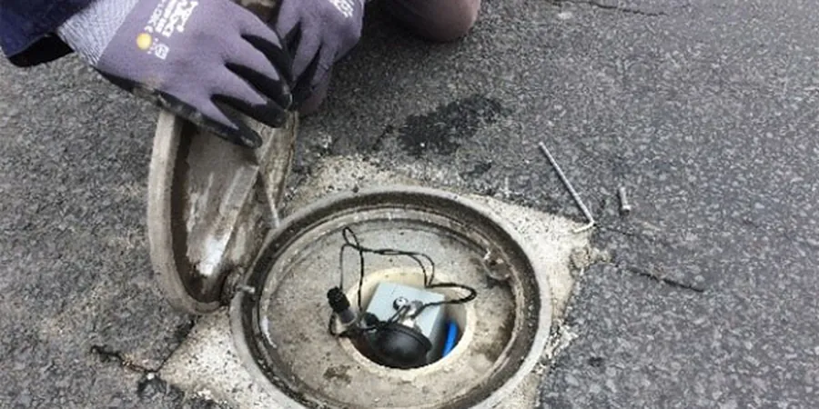
Technical reference image — Modesto
Local considerations
The main risk in Modesto is differential settlement caused by thin layers of soft silt sandwiched between sands. These lenses are hard to detect with borings alone. A 2020 warehouse expansion on Yosemite Boulevard saw 2.5 inches of settlement in one corner while the opposite corner moved less than 0.5 inches. The cause was a 4-foot-thick silt lens that only showed up after the inclinometer data was plotted. That is why we always pair instrumentation with a Cone Penetration Test campaign. The CPT gives continuous profiles that catch those thin soft layers. Without it, you risk cracking floor slabs and misaligned overhead doors within the first year of operation.
Vertical arrays of inclinometer casing and vibrating-wire piezometers installed in boreholes advanced through the upper 40 feet of alluvium. We grout the casing in place and run a baseline survey within 24 hours. Data is delivered via web dashboard with automated alerts when movement or pore pressure exceeds your threshold.
02
Settlement Monitoring Systems
Liquid-level settlement cells, plate settlement points, and automated tilt meters installed on grade beams, slabs, and fill surfaces. We connect them to a single datalogger with cellular telemetry. For Modesto projects on soft ground, we recommend weekly readings during the first 60 days of loading.
What is the typical cost range for a geotechnical instrumentation program in Modesto?
For a medium-sized commercial site (2–5 acres), expect a range between US$2,790 and US$3,630. This covers inclinometer casing, three vibrating-wire piezometers, a datalogger with cellular telemetry, and 90 days of data collection and reporting. Costs vary with sensor count and monitoring duration.
How deep do inclinometers need to be in Modesto's alluvial soils?
We typically install them to depths of 30 to 40 feet. That gets the bottom of the casing into the stiff clay layer that underlies the soft upper silts. If the project involves deep excavations or surcharge fills, we extend to 50 feet to capture any deeper movement.
What happens if an instrument is damaged during construction?
We design the system with redundancy. Critical locations get backup sensors, and all cables run in conduit protected by concrete curbs or heavy-duty covers. If a sensor is damaged, we can often replace it within 24 hours using spare ports on the datalogger. The monitoring schedule continues uninterrupted.