ASCE 7-22 requires site-specific ground motion analysis for Seismic Design Categories D through F, which applies to much of California's Central Valley. In Modesto, where the alluvial basin reaches depths exceeding 300 meters, seismic tomography provides the velocity structure needed for proper site classification. We deploy 24-48 channel seismographs with 4.5 Hz geophones along linear spreads of 100 to 300 meters to generate P-wave and S-wave velocity profiles. This data directly supports the determination of Site Class (A through F) per Chapter 20 of ASCE 7 and feeds into local response spectra for structural design. Before running full-waveform inversions, our team typically cross-checks surface data with existing borehole logs and [MASW surveys](/masw-vs30/) to validate the near-surface velocity gradient.
In Modesto's deep alluvial basin, combined refraction-reflection tomography resolves velocity inversions that single-method surveys miss, directly impacting seismic site classification.
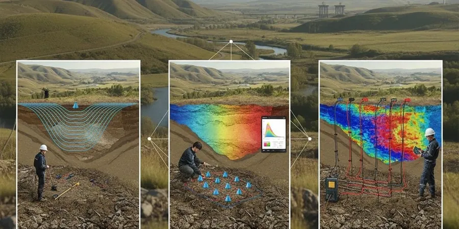
Methodology and scope
Modesto sits on deep Quaternary alluvial deposits from the Tuolumne and San Joaquin rivers, creating a thick sequence of sands, silts, and clays with occasional gravel lenses. The water table here fluctuates between 5 and 15 meters depending on irrigation cycles and seasonal recharge. These conditions demand careful survey design: refraction tomography works well when the velocity increases with depth, but when a high-velocity layer overlies a lower-velocity zone (velocity inversion), reflection processing becomes necessary. We combine both methods in a single deployment to handle the full velocity spectrum. Typical shot spacing is 5 meters with a sledgehammer source for shallow targets (down to 50 m) and accelerated weight drop for deeper profiling (100-200 m). Each survey line yields:
P-wave velocity structure (Vp) for lithological interpretation
S-wave velocity profile (Vs) for shear modulus and site class
Poisson's ratio field for identifying saturated zones
Depth to bedrock or competent stratum
For projects requiring near-surface Vs30 values, we cross-reference tomography results with dilatometer testing to validate stiffness profiles in the upper 30 meters.
Technical reference image — Modesto
Local considerations
The most common pitfall in seismic tomography within Modesto's alluvial environment is assuming a simple velocity gradient. The Tuolumne River deposits contain discontinuous gravel channels that produce lateral velocity contrasts, and the shallow water table creates a sharp refractor that masks deeper layers. If the survey geometry is too short or the geophone spacing too wide, these features are smeared rather than resolved. We mitigate this by running forward models before fieldwork to optimize shot and receiver layouts. In saturated low-Vs zones, the reflection stack can suffer from poor signal-to-noise ratio, requiring longer record lengths and lower-frequency geophones. Without proper processing, the resulting velocity model may misclassify the site as a stiffer class than it actually is, leading to under-designed foundations.
P-wave first-arrival inversion for shallow bedrock mapping, rippability assessment, and excavation planning. Ideal for infrastructure projects with depths up to 50 m.
02
Reflection Processing
Common midpoint (CMP) stack for imaging stratigraphic boundaries, faults, and buried channels. Used when velocity inversions or thin layers challenge refraction methods.
03
Combined Refraction-Reflection
Integrated survey using both techniques on the same spread. Produces a unified velocity model that compensates for the limitations of each method individually.
04
Vs30 and Site Class Evaluation
Dedicated S-wave tomography for shear-wave velocity profiling in the upper 30 meters. Directly feeds into ASCE 7 Site Class assignment and liquefaction triggering analysis.
Applicable standards
ASCE 7-22 Chapter 20 (Seismic Site Classification), IBC 2021 Section 1613 (Seismic Design), ASTM D5777-18 (Standard Guide for Refraction Seismic), NEHRP Recommended Provisions (Site Class Criteria)
Frequently asked questions
What is the difference between refraction and reflection seismic tomography?
Refraction tomography uses first-arrival travel times of direct and critically refracted waves to build a velocity model. It works best in normally-graded velocity profiles. Reflection tomography processes later arrivals (reflected waves) to image interfaces and structures. The two methods complement each other: refraction provides the background velocity field, while reflection resolves layer boundaries and velocity inversions.
How deep can seismic tomography profile in Modesto's alluvial soils?
With a 300-meter spread and an accelerated weight drop source, we routinely profile to depths of 120-180 meters in the Modesto basin. Deeper targets (200+ m) require larger sources like a seismic shotgun or vibroseis, which we can arrange for large-scale projects. The alluvial fill here is thick, so the maximum depth is limited by source energy and ambient noise rather than geological constraints.
What is the typical cost range for a seismic tomography survey in Modesto?
For a standard single-line survey with 24 channels and hammer source, expect costs between US$2,360 and US$4,950 depending on line length, number of shots, and processing complexity. Multi-line projects, weight drop sources, or combined reflection-refraction processing fall at the higher end. We provide a detailed quote after reviewing your site plan and target depth requirements.
How does seismic tomography data feed into seismic design per ASCE 7?
The output S-wave velocity profile is used to determine the average Vs in the upper 30 meters (Vs30), which directly classifies the site as A through F per ASCE 7-22 Table 20.3-1. The full velocity model also enables site-specific response analysis (Chapter 21), including amplification factors and design spectra. For liquefaction assessment, the Vs profile helps calculate cyclic stress ratios and resistance using the Andrus & Stokoe methodology.
Can seismic tomography detect buried channels or old riverbeds in Modesto?
Yes. Reflection tomography is specifically effective at imaging paleochannels and gravel lenses within the Tuolumne River floodplain. These features appear as lateral discontinuities in the stacked section and as velocity anomalies in the tomogram. Identifying them early prevents differential settlement issues and helps optimize foundation depths across variable subsurface conditions.