On a recent project along McHenry Avenue, the team was tasked with locating buried utilities before a road widening. The site had asphalt over lean clay with old irrigation lines, and no as-built records existed. Running a GPR survey in Modesto revealed not just the expected water and gas pipes, but also a forgotten 1950s storm drain running diagonally under the intersection. That find alone saved the contractor from a week of re-routing and potential damage claims. The GPR survey in Modesto uses 400 MHz and 900 MHz antennae to balance depth penetration with resolution, achieving around 2.5 m depth in the local clay-rich soils. Before finalizing alignment, the data was cross-referenced with a geotechnical instrumentation study to verify ground conditions around the found utilities.
In Modesto’s clay loams, GPR can resolve targets down to 2.5 m using 400 MHz — enough to catch most buried utilities and shallow voids.
Methodology and scope
Soils around Modesto are dominated by the San Joaquin series — deep, moderately well-drained clay loams with occasional lenses of sandy alluvium near the Tuolumne River. These clay-rich layers can attenuate radar signals faster than sandy soils, so the GPR survey in Modesto typically requires lower-frequency antennas (200–400 MHz) to maintain depth. The groundwater table fluctuates between 3 and 6 m depending on the season and irrigation cycles; below that, signal penetration drops sharply. Key parameters measured during a survey include:
Two-way travel time converted to depth using a dielectric constant of 6–12 for clay loam
Hyperbolic fitting from utility pipes and rebar to calibrate wave velocity
Amplitude mapping to distinguish metallic from PVC or concrete targets
Combining this data with a soil classification profile improves interpretation accuracy for foundation and utility projects.
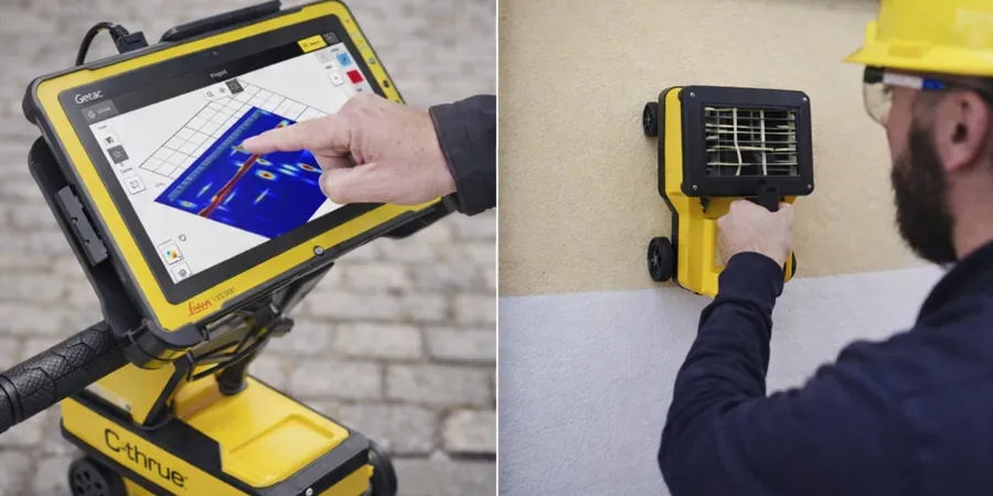
Technical reference image — Modesto
Local considerations
One thing that comes up often in Modesto is the presence of abandoned farm wells and old septic tanks from before the 1970s. These aren't on any utility map, and a standard potholing program can miss them if the search area is too narrow. A GPR survey in Modesto helps reduce that risk by scanning a wider footprint, but the clay content can mask smaller voids or non-metallic pipes if the dielectric assumptions are off. Calibrating the radar velocity with a known target — like a test trench or exposed pipe — is critical to avoid misinterpreting depth by 30 cm or more.
Pre-construction scans to locate metallic and non-metallic pipes, conduits, and cables. Results delivered as CAD overlays or GIS-compatible shapefiles with depth estimates and confidence ratings.
02
Void and Anomaly Detection
Identification of subsurface voids, sinkholes, or poorly compacted backfill. Used for pavement evaluation, foundation assessments, and environmental site investigations in Modesto.
Applicable standards
ASTM D6432-19 (Standard Guide for Using the Surface Ground Penetrating Radar Method), OSHA 29 CFR 1926.651 (Excavation and trenching requirements for utility location), ASCE 38-22 (Standard Guideline for the Collection and Depiction of Existing Subsurface Utility Data)
Frequently asked questions
How deep can GPR penetrate in Modesto soils?
In the typical clay loam around Modesto, a 400 MHz antenna reaches about 2 to 2.5 m. Using a 200 MHz antenna can extend depth to 3.5 m, but resolution drops. The high clay content attenuates signals faster than sandy soils, so site-specific calibration is essential.
Can GPR detect plastic or PVC pipes?
Yes, GPR detects plastic pipes because the electromagnetic wave reflects off the dielectric contrast between the pipe and the surrounding soil. PVC pipes as small as 5 cm in diameter are visible in Modesto's clay loam if the soil is not too conductive — wet clay can reduce visibility.
What is the typical cost for a GPR survey in Modesto?
For a standard utility survey on a residential lot, expect between US$1,230 and US$2,500. Larger commercial sites with grid scanning run from US$3,000 to US$7,540, depending on area and complexity. Contact the team for a detailed quote based on your project scope.
Do I need a GPR survey if I already have utility as-builts?
As-builts often lack horizontal accuracy or miss undocumented changes. In Modesto, many older properties have unrecorded irrigation lines or abandoned wells. A GPR survey validates the as-builts and catches discrepancies before excavation, reducing the risk of hitting an unknown line.